Nebraska's Wetland Complexes
In the Guide to Nebraska's Wetlan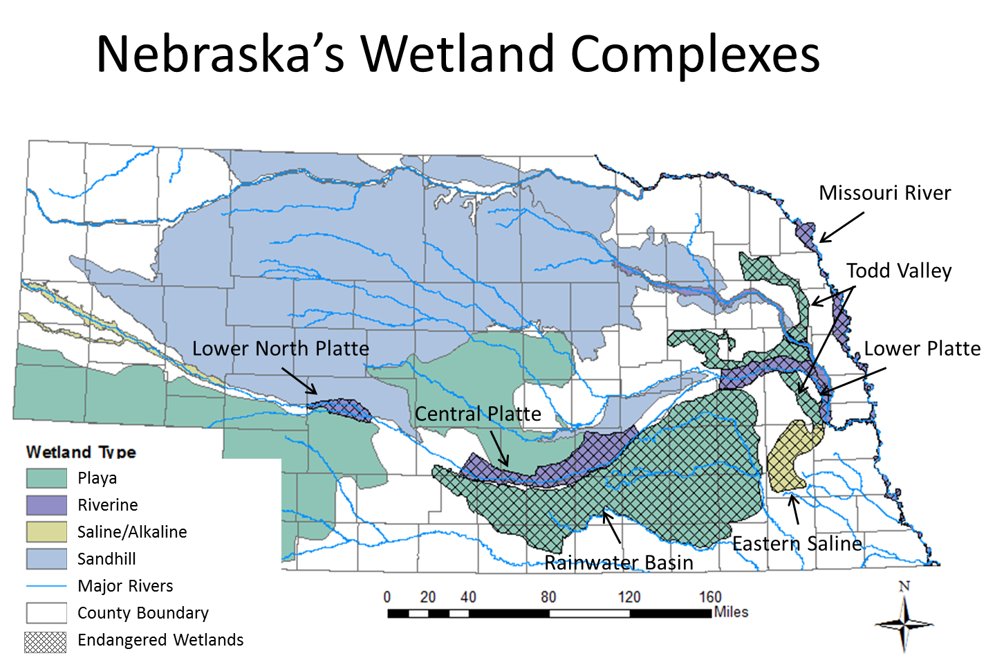 ds and Their Conservation Needs, four regional wetland categories and seven endangered wetland complexes were identified (LaGrange 2005). A complex is considered a geographically definable concentration of wetlands that are similar in form and function. In Nebraska, the four wetland categories are Playa, Riverine, Saline/Alkaline, and Sandhill.
Seven of the complexes were ranked in the Nebraska Wetlands Priority Plan as endangered based on wetland functions, losses, and threats. The complexes are Central Platte, Eastern Saline, Lower North Platte, Lower Platte, Missouri River, Rainwater Basin, and Todd Valley.
Central Platte
The wetlands and surrounding lands in this area provide habitat for several federally threatened and endangered species and is threatened by agricultural conversion, diminished flow, and altered sedimentation regimes. Each year, hundreds of thousands of Sandhill cranes (Grus canadensis) and the endangered whooping Crane (Grus americana) rest and feed in and around these riverine wetlands during spring migration.
Eastern Saline
These rare wetlands provide habitat for a number of resident and migratory species. The state and federally endangered Salt Creek tiger beetle (Cicindela nevadica lincolniana), one of the world's rarest insects, is known to occur only in these saline wetlands. More than 200 species of migratory birds have been recorded using the wetlands. Saltwort (Salicornia rubra), an endangered plant species in Nebraska, is only found in these wetlands and represent the southernmost permanent extant of the species. Once expansive enough to consider as for a salt mining operation, many of these wetlands have been lost due to urban expansion and agricultural activities.
Lower North Platte
The riverine and marsh-like wetlands of this complex provide staging areas for hundreds of thousands of Sandhill cranes during migration. Waterfowl and bald eagles (Haliaeetus leucocephalus) use the area both during migration and for wintering.
Lower Platte
This historically more wooded complex of wetlands provides habitat for migrating waterfowl as well as nesting habitat for wood ducks (Aix sponsa). Both the interior least tern (Sterna antillarum athalassos, state and federal endangered) and the piping plover (Charadrius melodus, state and federal threatened) nest on sandbars along the river and several great-blue heron (Ardea herodias) rookeries can be found in the area.
Missouri River
This wetland complex has experienced a great deal of destruction and degradation already. Yet, it provides habitat for nesting bald eagles, interior least terns, and piping plovers, all of whom are protected.
Rainwater Basin
The Rainwater Basin and adjacent central Platte River are complimentary and create a macro wetland complex that provide essential spring staging habitat for millions of waterfowl, shorebirds, and Sandhill cranes (Grus canadensis). The Rainwater Basin provides a unique resting and feeding location for birds during their northern migration. The network of shallow playa wetlands combined with nearby agricultural fields provides nutrient rich food sources needed by the birds to store energy during migration.
Studies conducted in this area indicate that many of the birds travel several kilometers (km) daily from roosting to foraging locations. Northern pintails (Anas acuta) fly, on average, 4.3 km during their evening forage flights (Pearse et al. 2011). Daily movements for white-fronted geese (Anser albifrons) and snow geese (Chen caerulescens) were 2.3 km and 3.4 km, respectively (A.T. Pearse, U.S. Geological Survey, unpublished data). In addition, Sandhill cranes were observed feeding up to four km from the Platte River, where they roost (Pearse et al. 2010). Bird use of individual wetlands can vary annually due to the dynamic nature of water availability; therefore, flight paths from roosting to foraging areas are variable.
Todd Valley
See Playa Clusters in Nebraska Section.
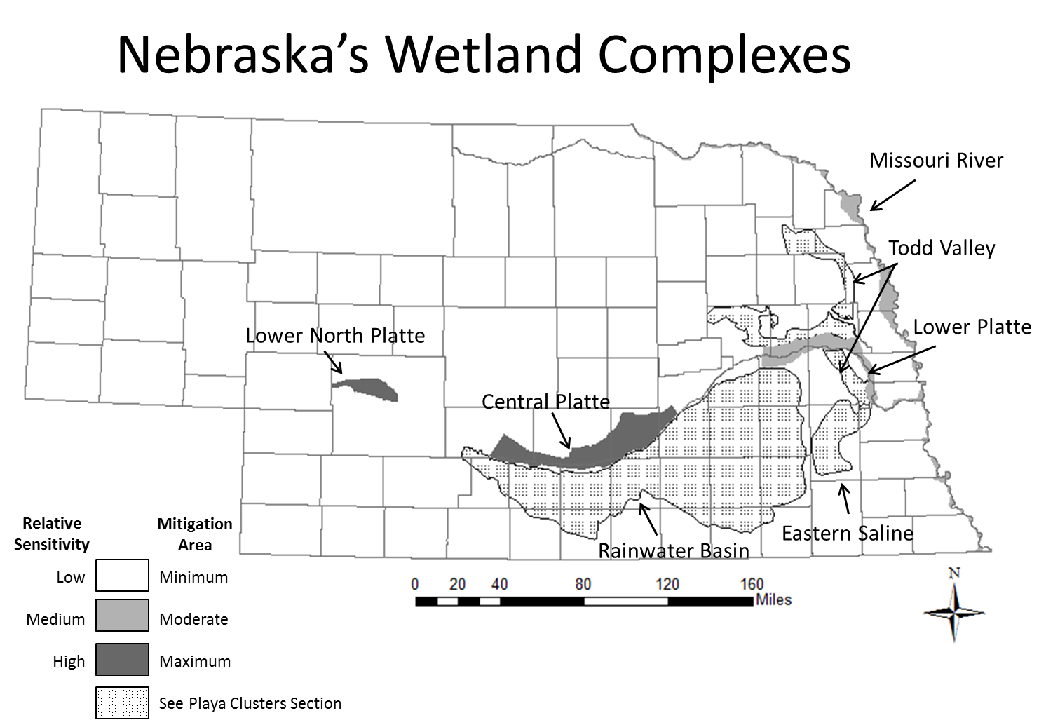
How this map was used: The Lower Platte, Missouri River, and Todd Valley wetland complexes were classified as Medium Relative Sensitivity and Moderate Mitigation Areas. The Lower North Platte, Central Platte, Rainwater Basin, and area of the Eastern Saline within Saline Wetland BUL were classified as High Relative Sensitivity and Maximum Mitigation Areas.